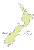
Haast is located within the South West New Zealand World Heritage Area.
This area was so designated for its outstanding natural beauty and habitats.
Read more about the Te Wahipounamu (South West New Zealand) World Heritage Area... (more details).
The Haast area is located along State Highway 6 at the southernmost extent of the Westland District on the West Coast of
the South Island of New Zealand.
This sparsely-populated area is made up of several small communities spread out over a 50km area.
The major settlements in the area are: The Haast Township on SH6, Haast Beach, Okuru, Hannah’s Clearing, Neil’s Beach and Jackson Bay all located along the Jackson Bay road.
Getting to Haast (& Travelling times)
Click here for transport options, detailed directions and travelling times
Maps
Click below to download & print a map of the Haast area (as a PDF).
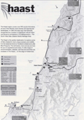 print map of Haast